Satellite Meteorology Resources
Browse the glossary using this index
Special | A | B | C | D | E | F | G | H | I | J | K | L | M | N | O | P | Q | R | S | T | U | V | W | X | Y | Z | ALL
A |
|---|
ApplicationsUSFS Fire Mapping http://activefiremaps.fs.fed.us/imagery.php NOAA Plume Trajectory Model http://www.arl.noaa.gov/ready/hysplit4.html | |||
C |
|---|
Climate and the Global Water Cycle Using Satellite DataPowerpoint presentation by John Bates, Chief, Remote Sensing Applications Division, NCDC
| |||
Climate Model "Noise"Radio Interview with Bruce Wielicki regarding clouds in the role of climate change.
| |||
Climate Model Uncertainties (Clouds)
Radio Interview with Bruce Wielicki via 'Earth & Sky' Radio Series
| |||
D |
|---|
E |
|---|
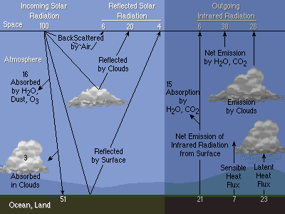
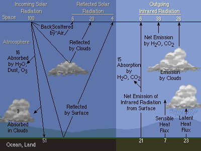
earth radiation budget
| |||
earth radiation budget-outgoing
| ||
L |
|---|
Learning ObjectsSingle graphics | |||
N |
|---|
NWP: vertical model resolution and satellite channel locationsThe attached .ppt slide shows the notion of how vertical resolution and top model level in an NWP model affects how (and whether) satellite radiance channels can be used for initial NWP analysis. The channels in the GOES longwave sounder are shown in terms of what pressures are covered and the weighting assigned to each as a function of pressure, while the vertical layers in the NWP model are shown at the right. PowerPoint animation illustrates the first three channels, and how the old North American Mesoscale model (NAM Eta), with a model top of 25-hPa and only 7 layers between 25-200 hPa, cannot resolve the radiances as well as the new NAM WRF with a model top of 2-hPa, and 9 layers over the same vertical range of pressures.
| |||
O |
|---|
ozone concentrationsreal-time ozone and aerosol data mapping and animations via satellite platforms for atmospheric chemistry and climage change | |||
P |
|---|
POES coverage | |||
POES data latencyPOES Data Blinds Delayed data shown in red. New ground stations will eliminate this problem. Data latency will be 2 hours or less. | |||
R |
|---|
Radiative ProcessesLecture notes from Professor Harshvardhan at Purdue University from his Introductory course in 'Survey of Atmospheric Science'
| ||
Radiative Transfer Models | |||
Recnent Events and Example Imagery | ||
S |
|---|
Satellite Platforms and Sensor ListU.S. Department of Commerce meteorological satellite sensors -- GOES U.S. Department of Defense satellite sensors -- DMSP DOC-DOD satellite sensors -- NASA meteorological satellite instruments -- Ozone Monitoring Instrument (OMI) | |||
T |
|---|
Technical Specifications and Calibration | |||
three orbit configurationNPOESS orbits One of the three satellites will be a European MetOp satellite to provide 6 hourly coverage | |||
Tutorials | |||