1st MSC Introductory Weather Radar Course
Why Use Radars for Weather Forecasting?
-
A vital tool for short-term forecasting
- Quicker and more frequent than satellite pictures (10 minutes or less per scan)
- Shows you where the rain is and how intense areas of precipitation are
- Shows where systems are in real time
- Not only where rain is, but how intense it is
- Movement of Tropical Cyclones, Thunderstorms and fronts
- Detection of severe thunderstorms - hail, tornadoes (if Doppler)
- Crucial part of nowcasting system
Tracking of boundaries such as sea breezes, convective outflow boundaries, wind shifts lines, front
|
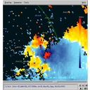
Detection of areas receiving rainfall (including some measure of rain intensity
|
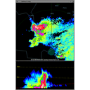
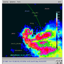
Location and severity of thunderstorms
|
Tracking of thunderstorm positions
|
Vertical wind profiler giving vertical wind profiles at least every 10 min
|
Ability to directly measure damaging surface winds
|
Ability to directly measure damaging surface winds
|
Ability to infer risk of large hail
|
Ability to infer risk of tornadoes
|
Ability to infer risk of tornadoes
|
Detection of smoke plumes from wildfires
|
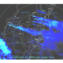
Tropical Cyclones – eye and rainband tracking
|
Summary of Features Detectable by a Weather Radar
-
Detection of areas receiving rainfall (including some measure of rain intensity
-
Tracking of boundaries such as sea breezes, convective outflow boundaries, wind shifts lines, fronts
-
Location and severity of thunderstorms including tracking of their positions
-
Vertical wind profiler giving vertical wind profiles at least every 10 min
-
Ability to directly measure damaging surface winds
-
Ability to infer risk of damaging winds, tornadoes, large hail and flash flooding
-
Detection of smoke plumes from wildfires
-
Tropical Cyclones - eye and rain-band tracking