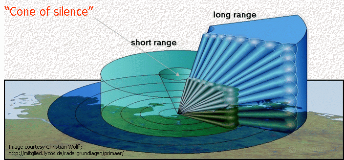
By scanning at a number of elevations from near horizontal to 30° or
40°, it is possible to build up a picture of the radar reflectivity
around the radar in three dimensions and so produce a fairly complete
picture of the location of precipitation both vertically and
horizontally (see Figure 1). This is known as volumetric scanning. From such a set of
scans it is possible, given adequate computing power, to put together
any of the conventional scans (PPI, RHI, or CAPPI) plus a number of
others. Other displays possible include Vertically Integrated Liquid
Water (VIL), the height of the tops of significant echoes, surfaces of
constant reflectivity and vertical cross sections along any line (not
just a radial as in RHI).
Figure 1: Illustration of Radar scanning angels and elevations showing the volume a radar can cover
Typically between 12 and 20 elevation scans are used to
construct a volumetric scan. A typical radar takes about 20 seconds to
complete each scan, and consequently a sixteen scan volumetric set will
take a little over five minutes to complete. This means that the data
captured at the top elevations of a volumetric set will have been
captured about five minutes later than the first scan. This can have
the effect of making a moving feature look as though it is tilted in
the direction of movement.
Volumetric data is usually collected at an azimuthal
resolution of 1 degree, a range resolution of 1 kilometre, and sixteen
reflectivity threshold levels. Thus the range resolution of the display
will, in most cases, be less than the maximum obtainable with the radar
(½ the pulse length).
The aim of radar scanning is to measure the 3 dimensional structure of reflectivity to obtain a “Volume scan”.
The number of scans is limited by the data collection rate (hence entire hemisphere is not able to be scanned!).