Quantitative
Validation of the precipitation measurements carried out with weather radars is done by comparing the measurements to the ground rain gauges. Validation results vary according to the local climatology and the setup of the radar and gain gauge networks. As an example, the following results were discovered in the RMI, Belgium:
- Range for reliable precipitation measurements is ~80-120 km in winter/stratiform conditions and ~150-200 km in sumemr/convective conditions.
- The radar tends to underestimate precipitation rates especially for winter/stratiform precipitation generated at low altitude
- Snow precipitation is generally underestimated
- Thunderstorm precipitations are well seen even at long range and generally not underestimated except in case of attenuation (occultation effect)
- Precipitation rates associated to hail falls are overestimated
To overcome the known and proven biases in radar precipitation measurements, a technique of gauge adjustment is used. Gauge adjustment is a simple and robust scheme adequate for operational use. The technique generally follows four steps:
-
For each station of the gauge network (climatological network)
- G (mm) = 24 h accumulation measured by gauge station
- R (mm) = 24 h accumulation estimated by the radar
- Fitting of R/G (expressed in dB) as a function of range
- R/G (dB) = 10 log10(R/G) = ffit (range)
- Adjustment of the radar 24 h accumulation image
- Validation
Fitting (2) is normally done using a second degree polynomial (see Figure below).

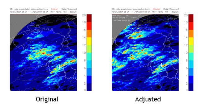
The figure below illustrates an original and an adjusted image of a 24h precipitation accumulation radar products. You can see how the precipitation is increased in the adjustment in the left-hand side of the image and on the top.