Classic
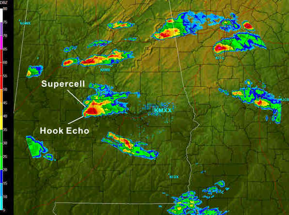
- An approximately elliptic horizontal cross section aloft, often larger in all dimensions than the typical non-severe storm. These storms are often characterized by a down-shear "V-notch" or "winged" appearance. An extensive plume is observed on radar and this forms part of a much larger visible anvil that extends downstream from the main storm core aloft. At low levels, the echo is situated mainly on the storm's left flank coincident with the forward flank downdraft but the echo may extend toward the right in the form of a hook-shaped appendage that is located mainly in the region of the rear flank downdraft.
- A persistent WER/BWER is found on the updraft flank. A WER is very common for most supercells, even those with weak mesocyclones. A WER is persistent, and capped by high reflectivities (>45 dBZ) above. The WERs not overlaid by strong reflectivities imply weak or no updraft, such as an overspreading, downshear, anvil layer. The WER is immediately adjacent to the low-level reflectivity core and bounded with high reflectivity gradients and on the storm-relative low-level inflow side. The BWER is less common but may also develop within the WER of the supercell. The BWER is conically shaped and decreases in width with height, extending to a height one-half to two-thirds of the storm depth. The BWER is indicative of a broad, strong (25 to perhaps 60 ms-1; 49 to 115 kts) updraft that contains small cloud particles but little precipitation. The storm top is located directly over the BWER and is over the updraft storm flank. When the storm is at moderate to long distances the BWER may not be detectable.
- A high-reflectivity core (the hail zone) extending all the way to the ground borders the BWER on its left and rear flank resulting in a strong reflectivity gradient there. The largest hailstones are typically located in the strong reflectivity gradient next to the BWER, with smaller hail and rain at increasing distances to the left and left forward of the BWER. This is a size sorting effect associated with the descent of hail within rising air that is also flowing toward the storm's left flank. The precipitation cascade downdraft owes its existence to precipitation falling out of the tilted updraft and evaporating in the midlevel stream of environmental air that enters the storm on the right flank. However, the primary downdraft, the RFD, is along the storm rear flank and extending into the hook echo. The RFD has proven to be crucial to the production of tornadoes but its origin is still unknown.
- An important period in the life cycle of the CL is the collapse phase. During this phase the echo top lowers, the BWER and WER disappear or are reduced, reflectivity and VILs often decrease, and the hook echo often "wraps up" and disappears. The echo then resembles the ordinary cell, rather than the supercell. While hail size decreases during this period the storm is often undergoing tornadogenesis and producing downburst and microburst winds. The tornado, if it develops, will often reach its maximum size and strength. After collapse, the storm often resembles a typical multicell cluster storm, but may recycle and become a reinvigorated supercell.
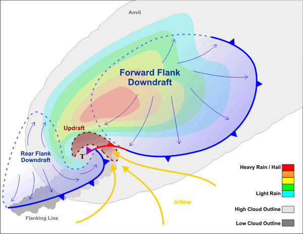
A top-down view of a classic supercell. Idealized radar reflectivity is color-coded, with red indicating heavy rain and/or hail. The curving shape of the updraft indicates rotation and the presence of a mesocyclone. The radar reflectivity in the immediate vicinity of the updraft is weak, suggesting that a supercell's updraft is sufficiently strong to prevent any precipitation that forms in this region from falling to the ground. The pendant-shaped 'swoosh' of blue and green radar reflectivity (relatively weak precipitation) on the backside of the mesocyclone is a hook echo. A supercell has two downdrafts associated with sinking currents of rain-cooled air. After downdrafts splash down, rain-cooled air spreads out along the ground. The leading edges of the rain-cooled air are outflow boundaries (gust fronts), which I designate here as cold fronts. If the supercell spawns a tornado (not all supercells are tornadic), the twister forms near the occlusion of the mesocyclone (marked by a 'T').
Courtesy of NOAA.