High Precipitation (HP)
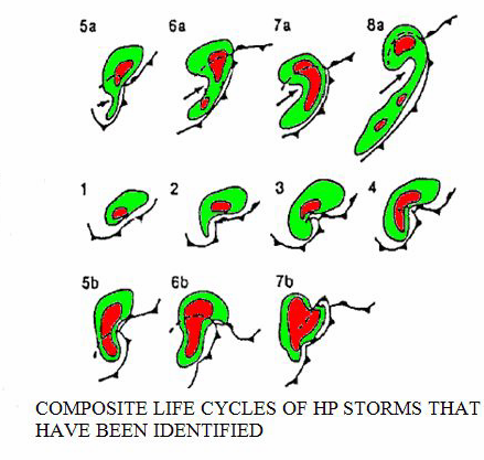
There is a wide variety of possible HP supercell configurations (see figure below). However, they all share traits common to supercells - an echo overhang and WER (sometimes a BWER), a displaced echo top and an inflow concavity, often on the front storm flank.
As with the Classic supercell, the inflow and mesocyclone are well correlated with primary updraft and the RFD and are typically long lived. The mesocyclone with the HP is usually well sampled by radar owing to the high reflectivities in the hook and circulation. But the correlation of the RFD with the precipitation cascade in the HP apparently often lead to a relatively cold RFD. Spotters in the field often have a difficult time observing the mesocyclone area most favorable for tornadogenesis. The updraft with its associated WER and BWER are often on the front storm flank. HP environments typically show more boundary layer moisture than that of LP or even CL. However, high boundary layer moisture is not necessary for HP occurrence. Another possibility includes low anvil-level, storm-relative flow (<18 ms-1) that apparently sometimes allows precipitation to reseed the updraft, improving precipitation efficiency (Rasmussen and Straka 1998).
A Classic supercell can evolve into an HP if it is being seeded by aggressive cells on its flanking line or adjacent storms. HP storms carry all threats of severe weather including strong tornadoes. However, the threats of large hail, damaging winds, and flooding are much larger than the tornado threat. Recent findings (Markowski 2001; Markowski et al. 2002) suggest that the RFD must be characterized by positive buoyancy and positive CAPE. Most often the RFD within HP supercells is heavy rain and hail laden and frequently "cold," lacking the needed buoyancy for tornado development.
References
Markowski, P. M., J. M. Straka, and E. N. Rasmussen, 2002: Direct surface thermodynamic observations within the rear-flank downdrafts of nontornadic and tornadic supercells. Mon. Wea. Rev., 130, 1692-1721.
Moller, A.R., C.A. Doswell III and R. Przybylinski, 1990: High-precipitation supercells: A conceptual model and documentation. Preprints, 16th Conf. on Severe Local Storms, Kananaskis Park, AB, Amer. Meteor. Soc., 52-57.