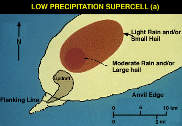
Low Precipitation (LP)
Low Precipitation supercells require significant instability and shear; however, other conditions help to reduce precipitation efficiency. Relatively shallow moisture and abundant dry air aloft reduce available moisture and add to entrainment. However, LP storms can also exist where boundary layer moisture is high. Additionally, very high storm-relative anvil-layer winds (>30 ms-1) transport rising hydrometeors well away from the updraft before they descend from the anvil Rasmussen and Straka 1998). Hydrometeors may have little chance of recycling back into the updraft, especially if the mid-levels are dry. LP storms are severe and produce large hail and, although rare, can produce weak to moderate tornadoes while appearing innocuous on radar. Significant tornadoes appear to be rare but they have occurred (Burgess and Davies-Jones 1979). LP storms that move into a region of deeper, low-level moisture may transform gradually into CL or even HP supercell storms.
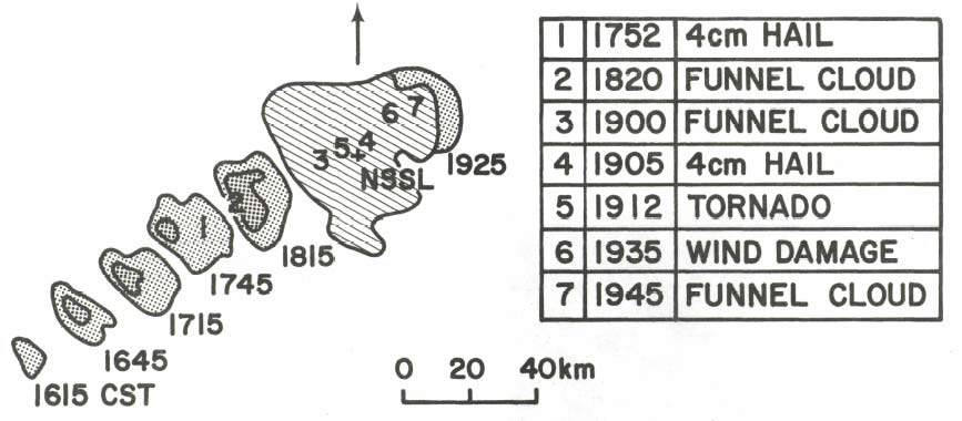
with that storm. Reflectivity contour values are 20 and 40 dBZ, respectively.
Hatching represents ground clutter (from Davies-Jones et al. 1976).
References
Bluestein, H. B., and C. R. Parks, 1983: A synoptic and photographic climatology of low precipitation, severe thunderstorms in the southern plains. Mon. Wea. Rev., 111, 2034-2046.
Burgess, D. W., and R. P. Davies-Jones, 1979: Unusual tornadic storms in eastern Oklahoma on 5 December 1975. Mon. Wea. Rev., 107, 451-457.
Davies-Jones, R. P., D. W. Burgess, and L. R. Lemon, 1976: An atypical tornado-producing cumulonimbus. Weather, 31, 336-347.