Multicell Storms
Multicell clusters and Lines will often evolve from merging Pulse storms or in situations where an environmental cap is “broken”, multicell clusters develop almost immediately.
- can evolve into lines or supercell(s)
- often well organized and long-lived
| Stage 1 |
 |
| Stage 2 |
 |
| Stage 3 |
 |
Schematic of the evolution of multi-cellular storms
Precipitation areas can be grouped into categories of size and lifetime. Observations show that synoptic areas that are larger than 104 km2 (2915 nm2) have lifetimes of one day or longer; large mesoscale areas that range from 103 to 104 km2 (291.5 to 2915 nm2) last several hours; small mesoscale areas that cover 100 to 400 km2 (29 to 116 nm2) last about an hour; and elements that are about 10 km2 (2.9 nm2) in size usually last no longer than half an hour.
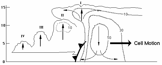
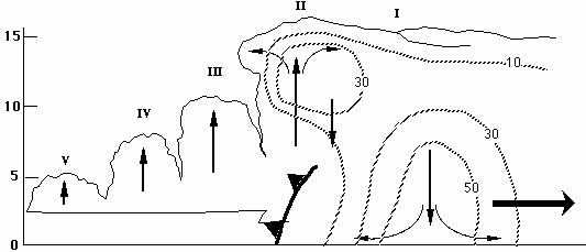
Along with the larger mesoscale features, typically the smaller deep moist convective elements have the highest rain rates and supply the major contribution to the total rainfall. Multicell storms are a common occurrence when deep, moist, convection organizes in clusters, lines, or areas. Multicells are defined in this text as a group of cells in close proximity sharing a common cold pool and precipitation area. In Maddox's (1980) classification of the Mesoscale Convective Complex (MCC), multicells could be thought of as belonging to both Linear and Circular types (Figure 7-3). The term Mesoscale Convective System (MCS) (Zipser 1982) includes all precipitation systems 20 to 500 km (11 to 270 nm) wide that contain deep convection. Examples in middle-latitudes are large isolated thunderstorms, squall lines, MCCs, and rain bands. The aerial extent of these systems is often too large to be covered by a single radar. Examination of mosaic maps from a network of radars is required to capture the full extent of many MCSs.
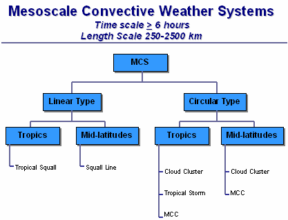
From Maddox (1980).
Source
Federal Meteorological Handbook no. 11: Doppler radar theory and meteorology, chapter 7, December 2005
References
Maddox, R. A., 1980: Mesoscale convective complexes. Bull. Amer. Meteor. Soc., 61, 1374–1387.
Zipser, E. J., 1982: Use of a conceptual model of the life cycle of mesoscale convective systems to improve very-short-range forecasts. Nowcasting, K. Browning, Ed., Academic Press, 191–204.