Introduction
In the case of a Warm Front, warm moist air moves against colder dry air. At the boundary of these two air masses the warm air tends to slide up over the wedge of colder air (see Typical appearance in vertical cross section). This process causes the frontal cloud band, and the associated precipitation, found mainly in front of the surface front (or the TFP).
The idealized structure and physical background of a Warm Front can be explained with the conveyor belt theory as follows:
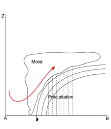
- Frontal cloud band and precipitation are in general determined by the ascending Warm Conveyor Belt, which has its greatest upward motion between 700 and 500 hPa. The Warm Conveyor Belt starts behind the frontal surface in the lower levels of the troposphere, crosses the surface front and rises to the upper levels of the troposphere. There the Warm Conveyor Belt turns to the right (anticyclonically) and stops rising, when the relative wind turns to a direction parallel to the front. If there is enough humidity in the atmosphere, the result of this ascending Warm Conveyor Belt is condensation and more and more higher cloudiness.
-
The Cold Conveyor Belt in the lower layers, approaching the Warm Front perpendicularly in a descending motion, turns immediately in front of the surface Warm Front parallel to the surface front line. From there on the Cold Conveyor Belt ascends parallel to the Warm Front below the Warm Conveyor Belt. Due to the evaporation of the precipitation from the Warm Conveyor Belt within the dry air of the Cold Conveyor Belt, the latter quickly becomes moister and saturation may occur with the consequence of a possible merging of the cloud systems of Warm and Cold Conveyor Belt to form a dense nimbostratus.